The East Asia-Asia Winter Wind system.
- The East Asia-Asia Summer Wind system.
- The East Asia-Asia Winter Wind system Part 1.
- The East Asia-Asia Winter Wind system Part 2.
- The weather breakdown.
- Winter Gallery.
In first order to understand the weather factors at work in a typical East Asia Winter Weather pattern from Late October to around March we will first study the effects of two weather factors that influence Asia in Summer and Winter.
- The Polar Jet/Westerly Jet.
- The Sub Tropical Jet.
The East Asia-Asia Summer Wind system.

In The above image (Asian Summer) we see that the two upper wind rivers are seperated by the large landmass that is asia. The Westerly Jet sits northbound over Mongolia and North China/North Japan and a large area sits within this south of the westerly jet before we encounter the second seperate wind jet the subtropical jet over the south of asia. The Westerly Jet sits higher in altitude then the near equator based Sub Tropical jet. So in the East Asia summer the two Jet stream systems remain north and south of Asia each on seperate wind jets.
The weather in Asia in summer then would become sometimes highly influenced by the Term Rossby waves affecting the STJ also in turn affected by a term called "Wet India-Dry Phillipinnes" that may bring severe rain and storm outbreaks to areas of South Asia. This is largely caused by South Asia Warming in Summer and the Monsoon pattern of Asia in summer. Variability influences this system.
This pattern above may then Bring Rains and Convection to India (Summer Monsoon) whilst in the Phillipinnes remains supressed storms and is influenced by the strength of the CBSISO (the boreal summer intra-seasonal oscillation) the key indicator for the Asian summer weather systems.
Rossby waves when south in summer interact to transfer cool air masses to near the equator where the cold air mass encounters warm air masses from the equator in a weather balancing act. One may see this in action over the south bay of bengal in the image but by there very nature tend to be very fast moving upper level winds within a slow moving upper level weather system. They are also dynamic in that they may distort and change shape over time (Elongate and then dissipate). They tend to be highly active over asia at times within the year and show variability that may bring Hot Dry weather OR Wet convection in summers.
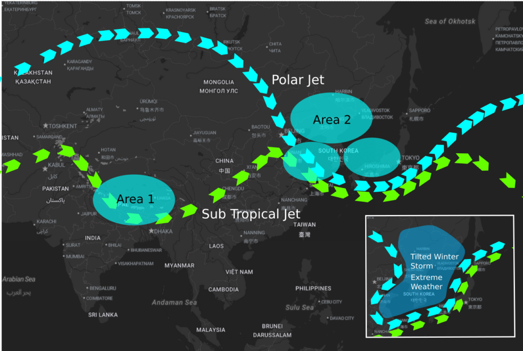
The East Asia-Asia Winter Wind system part 1.

In The above image (Asian Winter) we see that the two upper wind rivers being the Westerly Jet/Sub Tropical Jet are adjoined at North East China/The Korean Peninsula/Japan region and offer a list of imformation in concert.
- The Westerly Jet now more resembles the polar jet due to the presence of the Asian winter conditions and also through the presence of the polar vortex north of the Polar Jet that sometimes enlarges during the northern hemisphere winter months.
- Over the Himalayas there exists a Sub Tropical Trough (Western Disturbance rarer) created by the Sub Tropical Jet that combines with Himalayan Topology to bring extreme winter conditions whilst this pattern remains in place.
- The Jet positioning as shown above changes dynamically according to the Mid-Latitude weather influence (Moving West to East) in Winter and/or a phenom known as a Rossby Wave and/or the surface pattern of High-Low-High creating ridges and low pressure areas in the Asian winter weather pattern with the wind jet presence higher up in altitude. Usually cold fronts position at surface to this system in the low pressure region. Rossby waves are a product of a weaker Jet and then allows southern outbreaks of cold, they sometimes place more south but lately place north and are heavily influenced by variability.
- Hidden in this at area 1 the Himalayas and area 2 North East Asia in Winter there are what are known as pressure gradients ie:from a height on a slope as you get closer to the ground the air pressure drops at each slope graduation more so at ground level and are only present with low pressure systems.
- The Polar vortex can also in winter remain in the outer Arctic Circle when the Westerly jet is stable (Stronger) that normally prevents any southbound cold outbreaks. This creates a cold winter blast across the northern section of Asia where weather is consigned.
- Lastly we see above in the Asian Winter that the subtropical jet has moved northbound from the summer position.
The East Asia-Asia Winter Weather system part 2.
Now that we have covered the basics of the Upper Level summer/winter wind systems in Asia we now move to explaining the effects at surface this creates in the Asian Winter time from Late Oct to March. Please refer to the image above part 2 and the descriptions below.
The Breakdown Asia Winter Weather system.
Area 1:Himalayas and Central Asia.
- Due to the Himalayas Topology the High Altitudes here lower the air pressure of the mountain regions and the air pressure fluctuates according to the change in elevation of the terrain.
- This High Altitude then naturally provides a low pressure region and with the winter Polar Vortex cooling the North regions this cools down the asia region, the Himalayas becomes a large cooling box.
- With the presence of the Sub Tropical Jet Trough over the Himalayas this then lowers air pressure over the Himalayas even more that results in winter weather that may affect the Himalayas and East/South East of the region.
- It is important to realise that in the Himalayas during winter this then can lead to rapidly deteriorating weather that brings, freezing temperatures and sub zero conditions, snow, wind, ice, freezing rain, sleet in other words conditions are ripe for a snow storm.
- It is then important to prepare accordingly before the winter weather arrives in the mountain ranges.
Area 2:Korea/Japan/North China Nth East Asia.
- At the North East Asia/Mongolia area we find a changed topology and this brings more ground level weather to the area in winter also the area is closer to the polar vortex then other Asia areas.
- The winter Pressure gradient is more prevalent due to the upper low over the Nth East Asia area.
- With the combining of the Polar Jet and the Sub Tropical Jet in area 2 of North China/Korea/Japan/Yellow seas/East Mongolia upper level winds speed up that may create wind streaks that amplify winter weather effects.
- The drawing down of the wind river into the trough then also adds to the winter system effects that is unfolding in our example image.
- Winter Conditions will deteriorate in region 2 Nth East Asia as long as this pattern remains, known as moving in and will bring Cold Winter Temperatures at Zero at surface always and sometimes well below, The Yellow sea adds in moisture to create snow fall, a mild winter storm may form and the population prepares according to the Asian winter effect in Area 2 aka dress warmly avoid outside exposure use indoor heating.
Inset Area 2:Korea/Japan/North China Nth East Asia Extreme Tilt.
In the image above inset we see the Polar Jet/Sub Tropical Jet orientation is different showing effects of a tilted upper wind system in the Asian winter of Region 2 Nth East Asia. When this happens the tilted effect wind jet pattern being south west to north east will worsen weather effects felt on the ground and brings the extremest winter storms being whiteouts, heavy snow, extreme cold and major disruptions to ordinary life. It has been highlighted that this pattern is largely influenced by the Mediterranean sea weather and rossby waves.
Winter Gallery.


